“Moving to a new place can be a stressful event for many people, especially those are forced to move to a new address, as opposed to those who are buying or building a new house, or the people who want to move. And there are a lot of people who move quite a lot even though they don’t want to,” he says.
The study would be of assistance to policy makers and those looking at public health issues.
“If you know your population is fluctuating, this information will help decide on appropriate investment in housing development and may also shape how you design other services.”
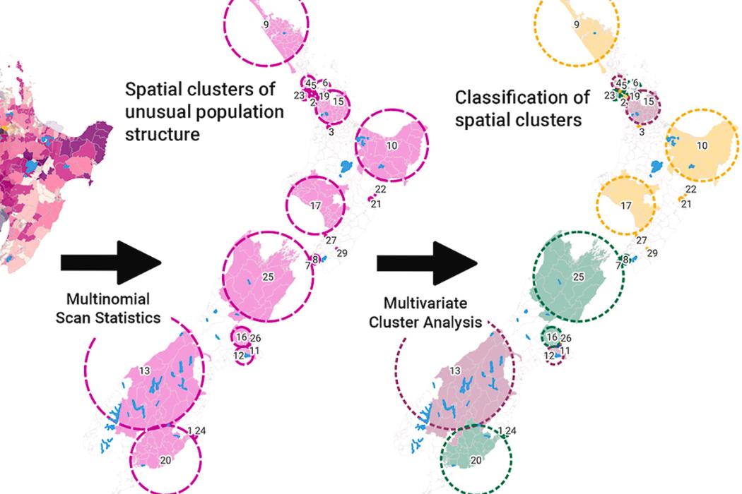
Socio-demographic and socioeconomic factors were incorporated into the study of data from 2016 - 2020, which maps spatial clusters of some of the most and least mobile groups. Transience, or home movement, was measured for every person in New Zealand through access to a national research database with individual and household-level microdata.
The study classified New Zealand areas into five groups based on shared patterns around their population’s movements.
Besides long-term “stayers” (southeast, excluding central Dunedin, and north of the South Island, outskirts of Christchurch, Wellington and Auckland), the study highlighted three distinct patterns for people moving home:
- New housing developments (group called “mobile non-vulnerable”) located nearby Auckland, Christchurch and Southern Lakes;
- People who move for educational and work opportunities (“mobile inner city”) – city centres of major cities;
- and potential reliance on social and cheap housing (“mobile vulnerable”).
Vulnerable transient populations were defined as people who moved at least five times within the most deprived areas of New Zealand (during the study’s timeframe), or 10 and more times regardless of the area’s socioeconomic status.
“For Māori, almost every 10th person was what we described as a ‘vulnerable transient’, compared to every 40th person for non-Māori, meaning you are about four times more likely to be moving homes at least once or twice a year or living only in the most deprived areas if you are Māori,” Dr Marek says.
A high percentage of people who are transient and vulnerable were based mostly in urban areas of Tāmaki Makaurau (Auckland), Whanganui, as well as around Te Tai Tokerau (Northland) and Tairāwhiti (East Cape).
Europeans and other ethnicities were highly represented in the stayers and mobile non-vulnerable people moving to new housing developments (noticeably south and west of Christchurch, in the Queenstown Lakes District and north of Auckland).
Dr Marek believes it is interesting to see a shift in what community might mean in New Zealand: “A lot of our small towns often have really mobile populations. What does that mean for a community?”
“The paper does give an idea about which parts of the country has longer-term residents (stayers) and which has more transient populations,” he says.
“For councils it may mean that if you’re designing services for stayers but you actually have very transient populations, you need to think about what will work and how you interact with those who reside in your area. You may be able to create better conditions for people who actually live in your area now.”
- The study ‘Towards a better understanding of residential mobility and the environments in which adults reside: A nationwide geospatial study from Aotearoa New Zealand’ is available at: org/10.1016/j.habitatint.2023.102762.
- National or international fast-food selling outlets
- Locally operated takeaways
- Dairy/convenience stores
- Fruit and vegetable outlets
- Supermarkets
- Physical activity facilities
- Alcohol outlets
- Gaming venues
- Green spaces (i.e. parks and forests)
- Blue spaces (rivers, lakes, sea etc)
Background
The Healthy Location Index (HLI) published in 2021 provided information for this 2023 study about “health-promoting” and “health-constraining” environments. Researchers for the HLI compiled “environmental exposure” data into 10 measures:
For more information on the HLI, visit https://tinyurl.com/goodsbads


.jpg)