

The Canterbury Plains are the largest region of flat land in Aotearoa New Zealand! Our current plate boundary began lifting up the Southern Alps at the headwaters of the Plains over 22 million years ago. Over time, the mountains became high enough to support substantial glaciation, which in turn increased erosion rates as glaciers carved their way down into the mountains, their weight exacerbating the incision between valleys and mountain tops. The rate of uplift accelerated dramatically during the last 5-7 million years and we experienced over 8 cycles of major glaciation episodes in the last 1 million years. Some of these glaciers extended all the way through the foothills to the western edge of the Plains, transporting vast amounts of eroded material into large braided rivers. These gravels and sands filled the continental shelf all the way out to the volcanic island of what is now Te Pātaka o Rākaihautū Banks Peninsula, and extended the Plains a further 50 km east of the current day shoreline! The last major glaciation ended only 14,000 years ago. Erosion has since then decreased dramatically, confined more largely to the mountain regions and focussed on the major river valleys (e.g. Waimakariri, Rakaia, Rangitata) which continue to shape the Canterbury Plains landscape today.
Braided Rivers
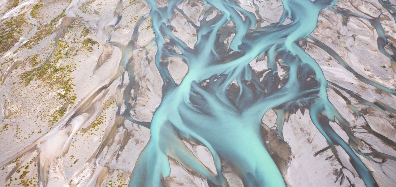
Braided rivers are integral to Aotearoa New Zealand landscapes, especially, but not uniquely, in Waitaha Canterbury. Braided rivers epitomise complexity and dynamism; yet they are fragile and sensitive to changes to flow, sediment supply, floodplain area, flood protection works, and encroaching vegetation.
Just as leopards are known for spots, braided rivers are known for dynamism. They move across, occupy, shape, and reshape large areas of New Zealand’s landscape, especially on the South Island. They are characterised by multiple shifting channels known as braids, wide floodplains and rapidly shifting braids, bars, and islands. Braids change course, shape, and extent with changes in sediment, hydrology, land use, vegetation, climate, and/or surrounding infrastructure. They move side to side, bifurcate then coalesce, and form islands or bars mid-stream. Active braids are often surrounded by currently dry land incised by previously active channels or floodplains. These now abandoned braids are not always visible without remote sensing technology such as LiDAR, that can reveal that the past wet state is a reasonably predictable future state for a particular place. In order to form, abandon, and re-form braids across wide “braidplains”. Braided rivers therefore require both large amounts of sediment coursing through their channels and “room to move”. The space and sediment requirements make braided rivers globally rare, and most often found in mountainous regions, where you have an uplifting (through tectonics) and highly erodible landscape.
At least 163 rivers in New Zealand have braided reaches, the largest and most iconic being in Waitaha Canterbury. Braided rivers are complex systems that encompass interactions between biology, hydrology, and geology.
He Awa Whiria
The analogy of a braided river encompasses the weaving of knowledge streams and systems, with shared understandings where they come together. This is expressed no more importantly when we weave together science with mātauranga Māori and other forms of indigenous knowledge, especially in the context of what makes a landscape and how we observe and understand it’s dynamic processes.

He Awa Whiria: a braided rivers approach (Macfarlane, Macfarlane & Gillon, 2015).
