

This sculpture is a joint collaboration between the School of Earth and Environment, the School of Civil and Natural Resource Engineering and Etesias, Italy.
Visualising fold structure is a highly important part of the field of structural geology and understanding the impact plate tectonics makes on the crust and rock layers. In Aotearoa New Zealand, because we straddle the active Australian and Pacific plate boundary, folds are most often directly associated with fault movements and stresses, and can provide clues to earthquake hazards or provide insights into fluid and gas resource storage (e.g. water, oil, natural gas and hydrogen).
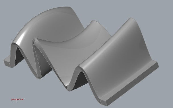
A fold is made up of layers of metamorphic or sedimentary rock bent into either an upwards closing shape (antiform) or a downwards closing shape (synform). Each fold has two limbs bent over a hinge or fold axis line. An imaginary symmetrical mirror plane through the centre of the fold is called the axial plane (see figure for labelled features).
Folds can be classified in 3-dimensions in the landscape with reference to geographic north using measurements taken with a geological compass. In order to classify a fold, you need two key measurements – the trend (direction of travel of a line feature) and plunge (angle/inclination under the ground) of the fold axis, and the strike (direction of travel) and dip (inclination of slope) of the axial plane. As simple as that may (or may not) sound, these are actually very difficult measurements to take in the field! Most times the folds are of huge scale over a large region and only fragments are exposed in the rocks at the surface. A geologist must piece together other measurements and plot them on a special 3D graph called a stereonet, in order to determine the full fold characteristics.
This sculpture allows structural geology students to practice taking many measurements on a variety of mini folds with different variables, representing models of real types of folds in the field.


